Lost Creek Wilderness {November 2011}

Labels

14ers (4) California (9) camping (23) Colorado (13) Family (2) Grand Canyon (7) Half Dome (5) Hiking (11) Italy (2) Medical School (3) Music (3) Notre Dame (2) Of random interest (3) Opinion (3) Photos (3) Poetry (1) Recipes (1) Snowshoeing (1) South Dakota (2) Travel (21) Utah (1)
Showing posts with label California. Show all posts

Thursday, August 11, 2011

Yosemite & the Sierra Nevada {Days 5 & 6}

Day Five, Tuesday June 21st: The Hetch Hetchy


Hetch Hetchy Valley
An environmental controversy throughout the early 1900s (as well as the potential indirect cause of John Muir's death), the Hetch Hetchy glacial valley in the less-traveled northwestern region of Yosemite was flooded by the O'Shaughnessy Dam through an act of Congress in 1913, thus forming the Hetch Hetchy Reservoir that now supplies water to some 2.4 million Californians west of the park. The dam marks the trailhead for the 14 mile round-trip trek to Rancheria Falls, the second of our backcountry destinations.


This area is held under strict security; the gated entrance only permits vehicle passage between 8 am and 9 pm during summer months {for this reason, we were forced to locate a campsite in the national forest subsequent to our late descent of Half Dome the evening prior}. Despite an early start, we were soon hiking in 95 degree weather ... thankfully this route passes underneath Tueeulala and powerful Wapama Falls, meaning we would be rewarded with a chilled glacial water soaking in less than 3 miles. After this, the remainder of the hike was rather uneventful (but certainly not for lack of scenery): wildflowers, tired legs, heat, and more wildflowers.


Tueeulala Falls

The 'trail' below Wapama Falls ~ a welcome respite from the heat
It is always discouraging to lose elevation when you know that you'll eventually need to gain it back; unfortunately, that's how the latter half of this hike felt to me. When we reached the designated backcountry campground, we continued on in search of a secluded site away from other campers as well as mosquitoes that tend to accumulate in the dense forest. Twenty minutes of exploration and significant bushwhacking was well worth the effort ~ we had a stunning view of Rancheria Falls! Unlike the dramatic plunge of Yosemite or Bridalveil Falls, the water that comprises Rancheria flows in a series of cascades more than 1,000 vertical feet to the Hetch Hetchy Reservoir below. This area is extremely serene and picturesque (below is our chosen campsite and the view) ...


Soon after our arrival, we assembled the tent, rearranged the fire ring, put the solar shower to good use, opened a bottle of Cabernet Sauvignon, strolled down by the water, accidentally stumbled upon a naked sunbather, and watched the sun set as rays of color dispersed through tree branches and reflected a golden light on the water's surface. While this area has an apparent reputation for aggressive bears (and, believe me, park rangers instill a very strong sense of paranoia), the bear canister containing our food was left undisturbed throughout the night and I have no bear sightings to report. The only bad news? Mosquitoes are ridiculously attracted to me; better here than malaria-riddled Africa I suppose.

Day Six, Wednesday June 22nd: Rancheria Falls to Sequoia/Kings Canyon National Park


Honestly, the return hike can easily be summarized through a couple of photos ...

Justin preparing for another intense soaking

When we reached the car in the overnight parking lot, we drove straight to the Evergreen Lodge (several miles down the road in Stanislaus National Forest just outside the Hetch Hetchy park entrance), sat down at the bar, and promptly ordered two bison burgers and two California draft beers. Though I have no idea about the accommodations, I would recommend this place based on food and beer selection alone. Feeling rejuvenated, we set out on the four hour drive that would take us through the Central Valley ~ where most of our fruit & veggies come from ~ and Fresno to Sequoia and Kings Canyon National Park (stopping briefly at both Washburn and Glacier Point, where the overviews of Yosemite Valley are unbeatable).

Half Dome, Vernal and Nevada Falls from Glacier Point

Thursday, July 28, 2011

Yosemite & the Sierra Nevada {Day 4}

Day Four, Monday June 20th: Half Dome

Standing on the summit of Half Dome subsequent to an unconventional climb felt remarkably absurd. In true Kat & Justin style, nothing about our experience was ordinary ~ enveloped by tranquility and a sense of accomplishment unlike anything I have ever felt, being here was the best moment of my life.


We had originally planned to climb Half Dome on June 21st as a day hike if we couldn’t secure a last-minute wilderness permit for Little Yosemite Valley. What happened next turned our frustration at rude and incompetent park rangers into awe at a chain reaction of favorable incidents. Upon extensive research, I discovered that we had the option to camp anywhere we wanted as long as we were beyond the designated campground and below a certain elevation. Although I explained this via telephone to Mark, an extremely unhelpful and bad-mannered park ranger, he denied any such camping existed and continued to berate me on my apparent lack of permit etiquette. Then, a few weeks before the trip, I finally managed to speak to a ranger who not only knew about the dispersed camping situation, but understood our dilemma and fixed it by issuing a wilderness permit then and there. He even rearranged the dates and changed our previously-confirmed Rancheria Falls permit to reflect the new schedule. Consequently, we were guaranteed camping solitude as well as the opportunity of summiting Half Dome on June 20th. One potential issue remained … the cables weren’t scheduled to be put in place for the season until Wednesday June 22nd, two days later.

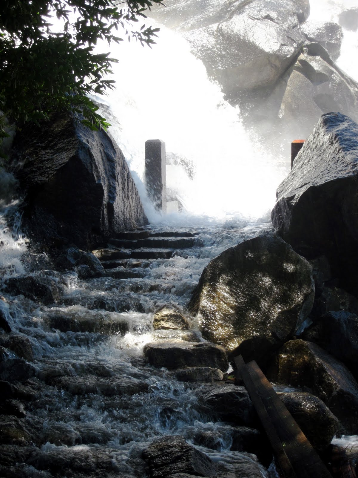
--- The braided steel cables are always on the mountain, it’s just a matter of whether they’re “up” or not. During the offseason, they simply lie on the rock and there are no wooden boards in place to use as footholds. When the snow situation has worked itself out, the cables are raised onto a series of metal poles at regular intervals so people can hold onto them at waist-level on both sides. Some claim that, when the cables are down, the Half Dome ascent becomes the province of climbers rather than hikers; this is entirely true.  ---

Just like the snowplows on Going-to-the-Sun Road and Tioga Pass, we continuously checked the status of the cables. Once we found out that they would not be in place for the day of our hike, we packed climbing gear and hoped for the best. This then explains my ominous thoughts the evening prior; photos of Half Dome without cables look downright petrifying. Moreover, the views from Olmstead Point and the Valley had made the climb appear nearly impossible. Even as we hiked the last few steps of the steep sub-dome and stood in plain sight of the dome itself, I said “There’s just no way” out loud, over and over.


I maintained this mindset even as we watched a few (literally, a few - it may as well have been deserted up there) people go up and come back down again. Though I love to climb mountains, I truly am wary of routes that combine height with significant exposure. After 30 minutes of analyzing, mentally preparing, and continuing to utter unsure statements (“You can go, and I’ll just wait right here on this rock for you”) something in me snapped. I fastened my harness, put my gloves on, and told Justin that we’d better go before I changed my mind.

A mere 400 vertical feet separated us from the summit of Half Dome ... it should take the average person about 15 minutes when the cables are in place and the crowd factor is a non-issue. For us, this section of the climb was quite labor-intensive requiring a strong grip and, primarily, upper body strength to pick the steel cables up and haul ourselves along while pausing every so often to clip in and out or switch cables altogether. Of course, I was shaking throughout the ascent … but I actually enjoyed myself! Climbing involves strategy and precision, both of which require attention and focus (making it more difficult to think about or look at how far down we could potentially fall). I did have a minor freak-out moment halfway up when I couldn’t find anywhere to put my feet while un-clipping and was saved, as always, by Justin’s calm attitude. Words fail me as I attempt to relay my feelings on the summit or describe the stunning views of Yosemite and its granite landscape from the best possible perspective in the park.


Each person we chatted with either on the summit or en route told us that going down was easier than going up. Not at all! I hated every second of the descent, and my lower back was painfully sore from tenseness for the next few days. The problem with going down is that you have to look where you’re going … down. It also took a while to figure out the best method (cable between your legs vs. cable off to the side). Justin had no trouble, as usual. Upon returning to the safety of the sub-dome, I almost started crying out of joy. We each opened a beer and toasted to a most unforgettable experience while gazing at the route we’d just taken up and back again; it still looked insane to me, maybe even more so.


The hike back to our campsite and the car was uneventful. We decided to take the John Muir Trail to avoid an inevitable soaking on the Mist Trail and to spare our knees unnecessary strain on those killer steps. On the way, we were rewarded with perfect views of our recent conquest as well as Nevada and Vernal Falls pouring into the Merced River below. We even met a man who could have been a modern John Muir himself: older, passionate about the wildness of Yosemite, and slightly crazed. I could imagine him speaking Muir’s words as if they were his own: ‘Climb the mountains and get their good tidings. Nature’s peace will flow into you as sunshine flows into trees. The winds will blow their own freshness into you, and the storms their energy, while cares will drop off like autumn leaves’.

Half Dome (left) & Nevada Falls from the John Muir Trail
And so concludes one of the most memorable days . . . 

PS: This is what the route looks like on a typical summer day when the cables are in place (the NPS does issue up to 400 permits per day). Thank God we were able to climb it under MUCH better circumstances!


-Details- 
Distance: approximately 16 miles round-trip from the Valley (and quite steep)
Elevation Gain: 4,800 feet
Summit Elevation: 8,842 feet
Time: 10-12 hours on average . . . I really can't be sure how 'long' it took us
Insanity Factor: 10 out of 10, easily (the way we did it)
Hazardous/Fatal? Mmmhmm!
Worth it? Totally

Tuesday, July 26, 2011

Yosemite & the Sierra Nevada {Day 3}

Day Three, Sunday June 19th: Across Tioga Pass, into Yosemite & up the Mist Trail

Last June, due to substantial snowpack that I imagine was even worse this year, Glacier’s Going-to-the-Sun Road failed to open in accordance with our plans. Not only does it present a huge challenge for plows in the spring, but it is the only road that bisects the park and allows for convenient east-west travel. As our trip neared, we obsessive-compulsively checked the plowing status every hour and were eventually forced to rearrange our initial schedule. On day seven, after having spent the past two nights on the boundary between Canada and the United States, we left Waterton and prayed the road would open so we could access the remote western side of Glacier. Minutes (literally) subsequent to its official opening, we were already on Going-to-the Sun driving west. While preparation certainly pays off, so does flexibility and the willingness to change your plans (which usually results in better circumstances anyway --- in this case, an improved schedule, hardly any traffic and the satisfaction of being among the first people atop Logan Pass for the season).

This year, the opening of Tioga Pass became an unexpected issue. The day before we left Denver, the NPS announced that the road would be passable beginning Saturday June 18th ... the day before we would be entering the park. Though it cannot compare to Glacier's 50-mile 'highway', Tioga Road does offer pretty spectacular views of Yosemite's granite peaks (including an introductory glimpse of Half Dome, the next day's challenge).


Half Dome from Olmstead Point
Yosemite in the summertime is an absolute zoo. I thought we would be off-season enough to avoid significant crowds in the Valley (and we were, it does get worse) … but still! If you have any sense at all, find your way into that backcountry as soon as possible! Unfortunately, we had to drive into Yosemite Valley to pick up our Half Dome wilderness permit; the entire ordeal cost us nearly two and a half hours, not counting the time necessary to locate the trailhead, pack our backpacks, and bear-proof our car. I was hoping we could reach our campsite with enough daylight to enjoy the Mist Trail and avoid unnecessary leg soreness. It felt strange to be hiking without proper park orientation … usually we spend the first night car-camping at an actual campground to get a better sense of our surroundings.

Yosemite Falls from the Valley
The Mist Trail is STEEP … prepare yourself for an intense workout, particularly if you intend to backpack. From the Happy Isles trailhead to our chosen campsite beyond Little Yosemite Valley, we hiked approximately 6.5 miles with close to 2,500 feet of elevation gain. The Mist Trail is also WET … prepare to get a good soaking from Vernal Falls, especially during spring and early summer (the snowpack as of April 1st this year was 178% of expected!!) But the rainbows, the views and the workout itself are absolutely worth every steep step. 

Vernal Falls (& Nevada Falls below)

Justin and I were both surprised at how quickly we reached Little Yosemite Valley, the designated backcountry campground for this area. However, our permit allowed us to create our own campsite at least a mile beyond as long as there was an existing fire ring and signs of previous impact. We found one about 100 feet off-trail and quickly changed into dry clothes before the mosquitoes descended upon our sweaty skin. I can’t even remember what we cooked for dinner; I was preoccupied with ominous thoughts that made me feel terrified and exhilarated, equally … we were going to climb Half Dome without the cables in the morning … 


Monday, July 25, 2011

Yosemite & the Sierra Nevada {Days 1 & 2}

The Sierra Nevada, less commonly referred to in its translated form (the Snowy Range) or as the Range of Light (John Muir)


My favorite photo of Yosemite Valley: Half Dome, Vernal & Nevada Falls from Glacier Point

June 17th-26th: Ten days across Utah, Nevada and California. This trip arose as the answer to a semi-serious question Justin and I asked ourselves upon returning home from the Grand Canyon in January: "Where should we go next?" By mid-February, we had most of the details worked out and by early March, we had secured permits for all of our backcountry outings as well as a day-hike permit allowing us to ascend Half Dome (Half Dome Cables). Additionally, we had reservations to stay overnight at Oak Flat fire lookout tower in the Sequoia National Forest on Friday June 24th. Early preparation truly does reward in an organized and stress-free trip, especially as the demand for permits in Yosemite and Sequoia/Kings Canyon National Parks is rather high, comparatively. Of course, we still left ample room for flexibility as we know that plans are often subject to the uncontrollable forces of chance and change (choosing a last-minute backcountry site in Yellowstone, Humboldt Peak route-finding, Going-to-the-Sun's delayed opening in Glacier, etc).

Day One, Friday June 17th: Denver to Great Basin, Nevada


Summer is undoubtedly the best season for road trips, namely because the sun does not set until well after 8 pm. Therefore, achieving a crack-of-dawn departure was not at all a high priority for us. Following a Starbucks and Einstein's stop, we left Denver around 7:30 am and arrived in Great Basin (near Baker, Nevada) a bit before 5 pm with plenty of light to spare. We chose a perfect primitive campsite along the Snake Creek, which was flowing high, and cracked a beer.


Before darkness set in, we played several games of horseshoes, photographed beautiful wildflowers, cooked salmon and asparagus for dinner, and chatted with a guy (the only one around) for a few minutes about his bird research -- actually, it probably ended up being nearly 45 minutes as he and Justin seemed to have many things in common. By nightfall, the calming sound of the creek made us tired and we fell asleep within minutes.

Day Two, Saturday June 18th: Great Basin to the Eastern Sierra


The Great Basin includes most of Nevada, half of Utah, and sections of Idaho, Wyoming, California and Oregon and is named as such because water drains internally - all precipitation either evaporates, sinks underground, or flows into saline lakes; there is no outlet to the Gulf of Mexico or the Pacific Ocean. Great Basin National Park preserves only a small piece of this entire 200,000 square mile region. On our drive towards the Eastern Sierra, where we'd spend the night, we passed through multiple basin-range alternating combinations ... this part of Nevada is quite pretty.

Black Rock Lava Flow

By late afternoon, we crossed into California and soon arrived, via scribbled-down directions, at a remote natural hot spring off Benton Crossing Road. Naked late-night hippies and Yosemite locals made this experience all the more interesting ... on the whole, a wonderful and unique way to celebrate two years of traveling, exploring and happiness together :)


Tuesday, July 5, 2011

Yosemite & the Sierra Nevada {Photo Link}

Because it will take some time to write an entry detailing this entire trip I will, at the very least, attach a link to an extensive photo album I've posted to my Facebook account. Enjoy :)

Wednesday, May 4, 2011

Wine, Food & Relaxation: the heart of Napa Valley

Despite three-hour long MCAT classes twice a week, and studying madly in between, I realize that I should briefly address my recent trip to the west coast (primarily through photos). The week can be described in a few simple words: wine, food & relaxation - everything a true vacation should be. We dined at world-class restaurants (including Bottega and REDD ... we decided to skip the notoriously overpriced French Laundry ...), tasted ridiculously good wine of many different grape varieties, and visited several interesting and unique vineyards during our stay in Yountville.


Domaine Chandon

Quixote Winery

Wine, cheese, olive oil, and chocolate tasting at Gabrielle's private estate & vineyard ~she also makes her own organic lavender products~

Napa Valley offered us a lovely time; I am happy to say that each visit to this region (November 2008 and now) left me feeling both refreshed and energized. From Napa, we drove through Sonoma and Point Reyes, where we opened a bottle of chardonnay on Limantour Beach, to San Francisco. Dan and Traci are doing so well, and little Bryce is the most adorable baby I could possibly imagine! It was such a treat to spend time with family that I don't see all that often :)


Enjoying a bottle of wine at Point Reyes National Seashore

Golden Gate Bridge

A gorgeous California poppy

California is a lush and beautiful place; I look forward to returning in June :)

Tuesday, April 5, 2011

'To find a queen without a king, / They say she plays guitar and cries and sings ... la la la'

Going to California (Led Zeppelin)


Welcome to Yountville

The link above will tell you anything you'd like to know about Yountville, California (at the heart of Napa Valley and, of course, wine country). I have been looking forward to this vacation for several months now, primarily because I'll be traveling with my parents. This is the equivalent of luxury - an idea I was somewhat accustomed to growing up ... an idea that has been overshadowed in recent years by a greater desire to explore the unfamiliar and exotic, to learn about the world on my own ... on a budget.

We leave on Thursday morning, and will be spending our first four nights at the Vintage Inn in Napa Valley. My father is an internist at Kaiser Permanente, and his well-chosen neurology conference is making this stint in gorgeous wine country possible. Thanks, Dad :)

On Monday, Tuesday and Wednesday, we'll be in San Francisco visiting my cousin Dan, his wife Traci, and their new baby boy, Bryce. I love this city and, despite getting violently ill on my last visit, I cannot wait to return! Dan and Traci are two of my favorite people on earth, and I am so anxious to meet baby Bryce (the photos and videos that I've seen are ADORABLE, and I don't typically find babies cute).

So, I guess I'm going to California!

Thursday, March 3, 2011

Half Dome Cables

Permit reservation day: 8 am Mountain Time, March 1st 

From Recreation.gov


Beginning in 2011, each person who ascends Half Dome via the Cable Route is required to have a permit every day of the week that the cables are in place (mid-May/early June through Columbus Day weekend in October, depending on snow conditions). Although wilderness permits can be secured up to six months in advance, a day-hike permit cannot be reserved until a specified date - in our case, March 1st.

You can only reserve a day-hike permit online through Recreation.gov as early as 7 am Pacific Time (8 am Mountain Time). Out of a 400 per-day permit quota, there were none remaining at 8:05 am for June 21st, the day we'd planned our climb. Within minutes of becoming available, every single day in both May and June was sold out {July hikes can't be reserved until April 1st, otherwise I can guarantee that the month would be sold out as well}. Thankfully, Justin and I were among the lucky 400 ... we had ours reserved and confirmed by 8:01!

Apparently I've underestimated the popularity of this hike (despite the craziness of day-hike permit demand). We'd been unable to obtain a wilderness permit allowing us to camp at Little Yosemite Valley on the night of the 20th (thus dividing our 17-mile round trip - & 4,800 feet of elevation gain - climb into two parts); every day through mid-August was completely reserved. However, the park service allows only 60% of these permits for any particular trailhead to be reserved ahead of time; the other 40% is held for hikers the day of travel, or up to 24 hours in advance. So, if we can make it to the wilderness office long before they open on the 19th, we should be good to go. If not, at least we've ensured a day-hike permit and the opportunity of a lifetime to climb this famous granite rock formation.


Monday, February 21, 2011

Two More on the Horizon

In the course of one extended weekend, I have had two seemingly successful medical school interviews (fingers crossed for Colorado!), and have entered into the planning stages for two upcoming road/camping trips (one small, one quite a bit larger).

In mid-March, my boyfriend Justin and I have decided to explore South Dakota for a few days. We’ll be able to bring our pup, Kona, since he loves the car – if not for the thrill of the ride, than certainly for the excitement awaiting at the end of the road – and make the easy six-hour drive to the Black Hills & Black Elk Wilderness in the southwestern corner of the state. Justin researched a few backpacking trails in the area, and found a promising loop allowing us to 1) travel a section of the Centennial Trail (110 miles long in total), 2) hike into Mount Rushmore National Monument, and 3) visit the interior of Black Elk Wilderness all in one short backpacking outing. To make the trip a bit more challenging, we’ll likely add a side-jaunt to Cathedral Spires, Harney Peak, or some other interesting destination. Of course, we’ll have to include a drive through the Badlands as well.

Our longer trip (minus the pup)? Ten days in California and the Eastern Sierra scheduled for late June! We’ll hit Great Basin, Nevada {which apparently has the darkest night sky in the continental United States}, the Eastern Sierra {including several remote hot springs}, Yosemite {hopefully getting the chance to climb Half Dome}, Sequoia and Kings Canyon National Parks, and Zion, Utah. I can hardly wait; the Sierra Nevada, for me, epitomizes new territory just begging to be explored!