I'll get right to it ... below is our proposed pre-trip plan, which we did indeed follow through with to perfection. I would easily suggest this or a similar route for exploring the unique environment of the Needles as it covers everything from a) descending into and climbing out of canyons b) hiking along the sandy bottom of canyons c) squeezing through narrow joints between canyons d) navigating over rocks and other fun obstacles e) up-close views of the sandstone needle formations f) a jaunt through the strange elevated grassland of Chesler Park, and g) ridiculous scenery with endless photography opportunities. Plus, I believe the route to offer a perfect balance among endurance training, adventurous playtime, and sweet relaxation ... ideal for a triathlete in training, experienced backpacker, or casual hiker.
Justin and I, eager for another backcountry adventure, began organizing our Canyonlands outing in late January. Hoping for sunny, snow-free, and warm
ish weather, we reserved our permits for backcountry campsites EC3 and CP1 as soon as we finalized our dates {2/21 - 2/26} to coincide with a new moon.
Why February? I cannot imagine who in their right mind would visit the high desert in summer's heat, let alone backpack through it, or during the more crowded spring and fall seasons.
Why EC3 and CP1? Thanks to those few backpacker/bloggers out there, we were able to view photos of both campsites and concluded that they'd best fit our needs ... there also seemed to be a general consensus that they're the best, period. We were not disappointed. Finally, w
hy a new moon? Much of Utah and the surrounding/neighboring Great Basin is ideal for stargazing ... and, through extensive research via
EarthSky, we discovered that Jupiter, Venus, Mercury, Saturn, and Mars would all be visible for the first time in years, as well as several bright stars near the constellation Orion that cannot typically be seen. Let me say, it truly was incredible -- and, if you take the time to gaze up at the night sky throughout March, the show will certainly continue.
Day One, Tuesday February 21st: Denver to Squaw Flat Campground, Canyonlands
Justin and I have the advantage of being the luckiest couple when it comes to timeframes and road trips; we happened to plan this one perfectly between two snow-laden winter storm systems in Utah and the Colorado mountains. Despite some snowpack on I-70, particularly near the Divide, we managed to reach the park boundary by 1:00 pm subsequent to a quick viewing of Newspaper Rock. The rock's surface features a concentrated collection of ancient Native American petroglyphs from various tribes, the oldest carvings dating back nearly 2,000 years! It requires only 3 minutes of your time, so do pull over and check it out.
 |
| Newspaper Rock State Historic Monument {along Hwy 211} |
 |
| Squaw Flat site #13 |
 |
| View from the cliffs above Squaw Flat |
I quite enjoyed Squaw Flat ~ the campground is more beautiful than online photos suggest, and the sandy environment is perfect for a game of horseshoes or bocce (we had both). If you're traveling in a larger group, each site has multiple tent pads and enough space to accomodate a number of people (though I think there may be a ten-person limit). Thankfully there were no such groups while we were there :) Thus, we enjoyed a few beers -including our sour cherry homebrew-, a gorgeous fire, grilled pork chops & sweet potatoes along with ample peace and quiet. I'm not sure about the pop-up van next to us though, the guy drove all the way to Canyonlands only to hang out in his vehicle ... in too close a proximity to our occupied site.
Day Two, Wednesday February 22nd: Elephant Hill TH to EC3
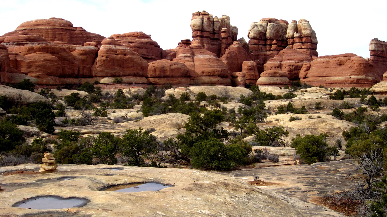
The dirt road from the campground to the trailhead is well-maintained, and we didn't come across another vehicle until we reached the parking area. Our photos will paint a much more accurate image of this route than my words ever could. Essentially, we climbed up a rock staircase or two, crossed over slabs of slickrock, marched through sand surrounded by cryptobiotic soil, passed between rock walls in narrow side-canyons, and eventually descended into Elephant Canyon on our 3.4-mile journey to EC3; it was fantastically fun.
 |
| How our backcountry trek began {just beyond Elephant Hill TH} |
 |
| An early view of the sandstone needle formations |
 |
| Fun trail segment/Make sure you have easy access to your camera |
 |
| Cryptobiotic soil (the black stuff) |
The descent into Elephant Canyon presents a unique challenge with a backpack loaded down with water and enough provisions for three nights. Since there are virtually no areas to collect water (yes, even in winter), that translates to a lot of extra weight on your back; just think of it as an added bonus on top of your already intense workout. Once in the canyon, EC1 is immediately visible. I half wished we could just set up camp there, but EC3 is literally a quarter mile or less down the sandy wash. The site is more dramatic than I imagined based solely on photos; we felt happy and cozy against the canyon wall, with a sweeping view of Elephant Canyon. The only downside I'd consider is the absence of afternoon sun since the campsite is so close to the west wall. But, who cares ... we were in Canyonlands! Shortly after setting up, we watched a lovely albeit brief sunset, heated up peanut butter & chicken chili (which we cooked the previous night over the fire ... so yummy), played a few games of Yahtzee, stared up at a very bright Orion, and finally snuggled into our sleeping bags.


Day Three, Thursday February 23rd: EC3 to CP1, with a day-hike to Druid Arch
The plan: French press coffee - 2.a little miles to Druid Arch - 2.a little miles back to EC3 - disassemble tent; pick up gear; bagel & salami; 2 miles to new campsite in Chesler Park. The hike along Elephant Canyon's wash and up to Druid Arch is a must-do. The last quarter mile is steep after following the flat canyon bottom, but we were up it in a flash. Be forewarned, it will most likely be windy at the top. Oh, and the ladder is mandatory ... and totally awesome!
 |
| Druid Arch |
Now, the 1-mile section that connects Elephant Canyon to Chesler Park was easily my second favorite part of our trek (after the Joint Trail). It was completely unexpected. The trail switchbacked up a steep red cliff from the sand below, disappeared into shady side-canyons on more than three occasions, and emerged to a most bizarre sight - Chesler Park.
 |
| Chesler Park |
 |
| A grand view of Elephant Canyon (though you can barely tell a canyon exists there) from Chesler Park |
As a campsite, CP1 is ideal. The afternoon sun shines brightly, rocks on all sides provide excellent shelter, the ground is sandy and soft, and you have front row seats to an incredible sunset over a backdrop of mesas and buttes. It's also a perfect basecamp for different day-hikes in the area.
 |
| The Moon & Venus (can't yet see Jupiter) |
Day Four, Friday February 24th: Chesler Park day-hike loop
After backcountry pancakes and maple syrup, we chose to hike counterclockwise around Chesler Park; the photos can speak for themselves. The Joint Trail is too cool.
 |
| Massive playground |
 |
Along the Joint Trail
Unfortunately, it seems that the cairn cavern I was so excited to visit no longer exists. Of course the cave is still intact, but there was just one lonely creative cairn that I could find ...
|
The entire 5.1-mile loop probably took us three hours at a decent pace; we were back to CP1 with plenty of daylight to spare, beers to consume, and bocce to be played. Blessed with another splendid sunset and an unobstructed night sky view we thought, 'ah, life is good' :)
Day Five, Saturday February 25th: CP1 to Elephant Hill ... and Denver, Colorado
A strange, high-pitched, and methodical sound woke us early the next morning. Oh yes, we had set the alarm (phone) for sunrise - around 6:45 am. I glanced down only to find that the phone had in fact lost a full charge of battery overnight ... thankfully the squawking raven just outside our tent was on top of things. We had no idea what time it was when we left camp, but the angle of the sun and the length of our shadows both suggested that it was early. The 3-mile hike from CP1 back to Elephant Hill was quite ordinary; however, we did come across the above walrus/gnome hat/melted hershey formations that I found amusing. Surprise, surprise, we reached the car at exactly 9:58 am! I would have been happy with noon ...
What would you consider to be a perfect ending to a flawless trip? Hot $3 showers at the
Lazy Lizard {a colorful hippie commune located along Hwy 191 as you enter Moab} and microbrews at the
Moab Brewery? Precisely. Be sure to try their oatmeal stout. Justin and I had initially planned on camping at a designated BLM campground just outside of Moab on Hwy 128 so we could unwind and enjoy a fire (wood fires are prohibited in Canyonlands backcountry). Each campground (
shown here) was
supposed to be open year-round. Suffice it to say, we were back home in Denver before we knew it. I think a few of the campgrounds were actually open, but once we drove past them in search of greener pastures there was no turning around.
This itinerary worked incredibly well for us and, as I said before, I would recommend it to anyone and everyone heading towards Canyonlands. Justin and I have both seen and visited some remarkable places in this world, but Canyonlands is unlike anything ... the best way I can think of to describe it is a ridiculously fun and uniquely beautiful natural playground. I can guarantee we will be back to explore another district in the near future, most likely the more remote Maze :)
Happy Travels!